
Updated Earthquake Zonation Map Reinforces Northeast’s High Seismic Vulnerability
ByNE Times Desk
Dec 3, 2025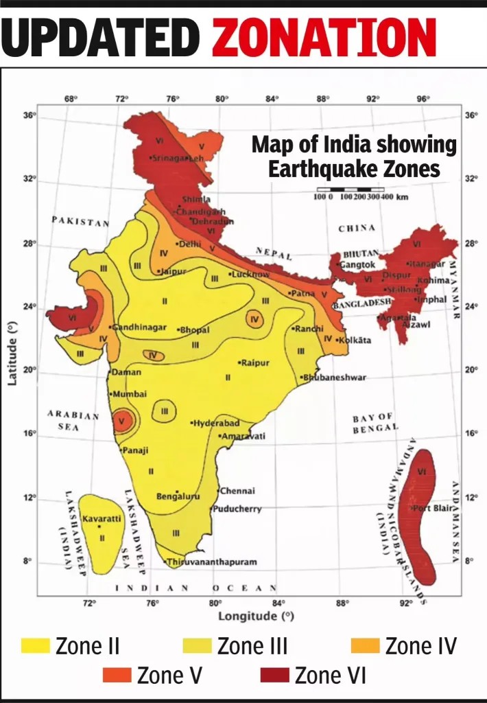
New Delhi: The Bureau of Indian Standards (BIS) has released a revised Seismic Zonation Map under India’s updated Earthquake Design Code 2025, reflecting the latest geological and seismic research. The new map accounts for active and dormant fault lines, tectonic stress build-up, recorded earthquakes, and predicted ground-shaking intensity across the country.
A key revision includes the reclassification of Dehradun, which has now been moved from Seismic Zone IV to Zone VI, placing it among India’s highest earthquake-risk areas. The shift is expected to trigger significant changes in building rules, retrofitting requirements, and construction compliance, especially for public and high-rise structures.
Northeast India Remains Among India’s Highest-Risk Seismic Zones
According to the revised zonation, all Northeastern states – Assam, Arunachal Pradesh, Manipur, Mizoram, Meghalaya, Nagaland, Tripura, and Sikkim – remain under Zones V and VI, reaffirming the region as one of the most vulnerable seismic belts in South Asia.
The Northeast sits on the complex convergence of the Indian and Eurasian tectonic plates, including several active fault systems such as:
- The Main Boundary Thrust (MBT)
- The Indo-Myanmar Arc
- The Brahmaputra Fault System
- The Dhauki and Kopili Fault Zones
Historically, the region has experienced some of India’s most powerful earthquakes, including:
- The 1897 Assam Earthquake (Magnitude 8.1)
- The 1950 Assam–Tibet Earthquake (Magnitude 8.6) — one of the strongest recorded globally.
Seismologists note that accumulated stress along these systems indicates the possibility of future “great” earthquakes, making the new zoning especially significant for urban centres like Guwahati, Shillong, Aizawl, Kohima, Imphal and Itanagar.
Urgent Need for Preparedness and Compliance
Experts say the revised map should serve as an alert for policymakers to:
- Strengthen enforcement of earthquake-resilient building codes
- Retrofit vulnerable schools, hospitals and heritage structures
- Improve urban planning in expanding cities
- Expand community-level drills and emergency response mechanisms
Disaster-resilience researchers also warn that rapid urbanization in the Northeast – particularly unregulated hill construction and deforestation -may increase the impact of future earthquakes unless corrective planning measures are taken.
The updated BIS map is expected to guide infrastructure development, insurance assessments, and national disaster reduction strategies in the coming years.
Source: Bureau of Indian Standards (BIS)
- Compiled by Dipanjana D.